Services — Numerical Modeling RMA Bay-Delta model
The RMA Bay-Delta model is a well-established tool for analysis of the hydrodynamic and water quality impacts of proposed projects in the San Francisco Bay and Sacramento-San Joaquin Delta.
The RMA Bay-Delta Model was one of the primary tools used for the Bay Delta Conservation Plan (BDCP) evaluation of tidal marsh restoration and has been used extensively in the development of the Suisun Marsh Programmatic EIR/EIS.
Since 1996, the model has been used for analysis of:
- Wastewater discharges, including dilution, dissolved copper and nickel, coliform, pathogens and nutrients
- Levee failures (from single breaches to seismically induced delta-wide failures), their impact on water quality and Delta operations, and the effectiveness of emergency response measures
- Tidal marsh restoration projects and their impact on hydrodynamics, tidal mixing and water quality in the Delta
- Hydrodynamic and water quality impacts of Delta Cross Channel reoperation and installation of various gates and barriers throughout the Delta
- Fish behavior based on flow, salinity and turbidity conditions
- Flood events
- Drought conditions
- Nutrients and temperature
- Sea level rise
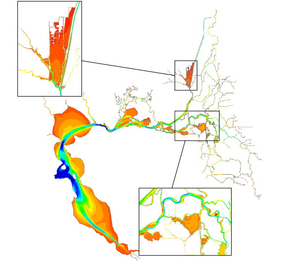
Model grid and bathymetry of the RMA Bay-Delta Model.
The RMA Bay-Delta Model accurately simulates of Delta-wide hydrodynamics and water quality transport. In addition to standard water quality simulations, the model can be used in particle tracking mode to evaluate fish behavior or simulate the generation and dispersal of phytoplankton.
The RMA Bay-Delta Model utilizes the RMA2 hydrodynamics and RMA11 water quality transport finite element computational engines. The finite element model formulation allows use of an unstructured computation mesh where resolution can be increased locally to represent the topographic details of a restoration site. The RMA2 and RMA11 engines support combining 2D depth-averaged computational elements and 1D cross-sectionally averaged elements in a single mesh. In the RMA Bay-Delta Model, all large channels, embayments, and tidal marsh restoration areas are represented in 2D.
The RMA Bay-Delta Model does not directly simulate the effects of stratified flow, which would require application of a 3D model. The effects of stratification and gravitational circulation are approximated in the model through inclusion of a horizontal Richardson number and the calibration of mixing coefficients to best represent the observed salinity field for a historical period, or to best represent the computed salinity field from a 3D model simulation for a proposed condition.
Applications of the RMA Bay-Delta Model
| Project | Project Period | Client |
|---|---|---|
| Particle Tracking Simulations Supporting USGS/Tamara Kraus’s Sac Regional Wastewater Hold Experiment and USGS Sampling Scheme | 2014 | USGS and Central Contra Costa Sanitary District |
| Dilution Analysis of Novato Sanitary District’s Proposed Discharge to Bel Marin Keys Unit V | 2014 | Novato Sanitary District and California State Coastal Conservancy |
| Numerical Modeling in Support of the 2014 California Drought Response | 2014 | State Water Contractors and Metropolitan Water District of Southern California |
| Dilution Analysis of Palo Alto Regional Water Quality Control Plant’s Discharge to South San Francisco Bay and Matadero Creek | 2013-2014 | City of Palo Alto |
| Numerical Modeling support for restoration studies in Suisun Marsh | 2013 | California Department of Water Resources, Division of Environmental Services |
| Initial Modeling of Local and Regional Impacts of the Proposed Tule Red Tidal Marsh Restoration, Grizzly Island, California | 2013 | Westervelt Ecological Services |
| Hydrodynamic and particle track modeling in support of salmon out-migration studies | 2012-2014 | USBR and USGS |
| Incremental Impacts of Central Contra Costa Sanitary District’s Discharges to the San Francisco Bay-Delta System | 2012-2014 | Central Contra Costa Sanitary District |
| Analysis of Tidal Restoration of Prospect Island | 2011-2014 | California Department of Water Resources |
| Real-time modeling of Hydrodynamics, Salinity, Turbidity | 2010-2013 | Metropolitan Water District of Southern California |
| Delta Flood Modeling for the Central Valley Flood Protection Plan | 2010-2012 | California Department of Water Resources |
| Hydrodynamic and Salinity Impacts Modeling for Bethel Island, Horseshoe Bend - CalFed Levee Stability Program | 2010 | US Army Corps of Engineers Sacramento District |
| Delta Wetlands Particle Track Modeling for Island Diversion Alternatives | 2010 | Delta Wetlands |
| Far Field Dilution Analysis of the City of Modesto Water Quality Control Facility Discharge | 2010 | City of Modesto |
| RMA Particle Track Modeling of Fish Screen Alternatives for Existing Delta Export Facilities | 2010 | MWH |
| Water Quality Impacts of Pinole-Hercules Water Pollution Control Plant Discharge in San Pablo Bay | 2009 | City of Pinole |
| Numerical Modeling of the WERF Wet Weather Blending Project Discharges to San Francisco Bay | 2009 | East Bay Municipal Utilities District |
| Impacts of Delta Diablo and Central Contra Costa Sanitary Districts Waste Water Recycling on Salinity Concentrations in San Francisco Bay | 2009 | Delta Diablo Sanitary District and Central Contra Costa Sanitary District |
| Franks Tract-Three Mile Slough Pilot Project | 2008-2013 | California Department of Water Resources, USBR |
| Hydrodynamic, Salinity, and Particle Transport simulations for analysis of the proposed “Two-Gates” pilot project | 2008-2011 | Metropolitan Water District of Southern California |
| Water Quality Impacts of Delta Diablo Sanitation District Discharge in New York Slough and at Nearby Water Intakes | 2008-2009 | Delta Diablo Sanitation District |
| Numerical Modeling of Central Contra Costa Sanitary District Discharge in San Francisco Bay | 2008 | Central Contra Costa Sanitary District |
| 2-D Hydrodynamics for Ship Simulation Studies | 2008 | US Army Corps of Engineers San Francisco District |
| 2-Dimensional Modeling in support of the Bay Delta Conservation Plan | 2007-present | SFWCA, California Department of Water Resources |
| Habitat Management, Preservation, and Restoration Plan for Suisun Marsh Programmatic EIR/EIS | 2006-2010 | California Department of Water Resources |
| Delta Risk Management Strategy (DRMS) – modeling of multiple levee breach scenarios in the Delta | 2006-2009 | California Department of Water Resources |
| Delta Modeling Support for Delta Cross Channel reoperation, Through Delta Facility analysis, and Franks Tract alternative analysis | 2006-2008 | California Department of Water Resources |
| Numerical Modeling of Delta Levee Breach Scenarios with Emergency Response | 2006-2007 | Metropolitan Water District of Southern California |
| Jones Tract Levee Breach Simulation | 2006 | California Department of Water Resources |
| Near and Far Field Dilution Analysis of the Manteca Wastewater Discharge | 2005-2006 | City of Manteca |
| CALFED Flooded Islands Study – analysis of opportunities to manage tidal mixing in and near Delta flooded islands | 2004-2006 | CALFED |
| Numerical Modeling of Discovery Bay | 2004-2006 | Reclamation District No. 800 |
| CALFED Levee Risk Assessment - preliminary modeling of large scale flooding of the Delta due multiple levee breaches | 2003-2004 | CALFED |
| Mathematical Modeling of Hydrodynamic and Water Quality Impacts of the Tule Belle Micro-tidal Restoration Project | 2002 | CALFED Suisun Marsh Levee Investigation Team |
| Evaluation of the EBMUD Discharge to Central San Francisco Bay | 2001 | East Bay Municipal Utilities District |
| Mathematical Modeling of Hydrodynamics and Water Quality Impacts of Suisun Marsh Levee Breaches | 1999 | CALFED Bay-Delta Program |
| Impacts of the BADA Discharges on Copper Levels in the San Francisco Bay | 1998 | Bay Area Dischargers Association |
| Evaluation of the City of Palo Alto Treated Wastewater Discharge to South San Francisco Bay | 1997 | City of Palo Alto |
| Evaluation of Novato Sanitary District Treated Wastewater Discharge to San Pablo Bay | 1996 | Novato Sanitary District |