Services — Numerical Modeling RMA 3D San Francisco Estuary Model
RMA’s 3D hydrodynamic and water quality model of the San Francisco estuary predicts water surface elevations, flows, 3D velocity structure, salinities, particle transport, and water quality throughout the San Francisco Bay and Delta. Specific model grids have been developed to simulate the present-day Delta as well as the historical (pre-development) Delta. This allows us the unique opportunity to investigate issues facing the contemporary Delta and be able to compare results to conditions present in the natural Delta.
Built around the UnTRIM computational engine, the model was developed in collaboration with the University of California Davis Center for Watershed Sciences and has capabilities to account for:
- Time dependent inflow, stage, and salinity boundary conditions
- Delta Island Consumptive Use
- Gate operations and temporary barrier installations
- Vertical turbulence closure scheme, contributed by the Bundesanstalt für Wasserbau (BAW)
- Spatially variable bottom roughness coefficients
- Wind stress forcing at the water surface
- Spatially variable, time dependent specification of evaporation and precipitation
- Spatially variable water surface elevation and salinity initial conditions
- Restart and model log file creation
- Compact output file creation
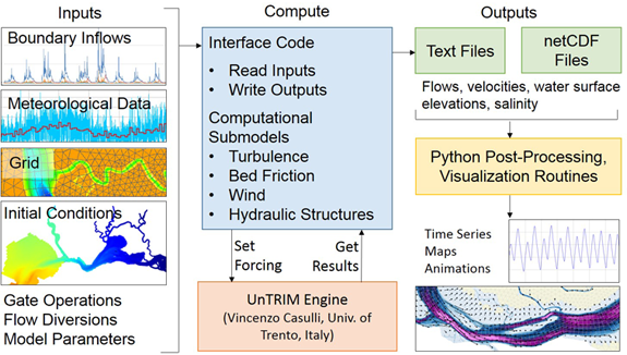
Computational framework of the RMA 3D San Francisco Estuary Model
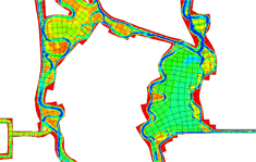
Subgrid bathymetry example showing area around Mildred Island
Our unstructured orthogonal grids were created using the Janet grid editor and targeted moderate spatial resolution in order to run long term simulations of the full Bay-Delta system quickly and efficiently. The grids utilize subgrid methodology, whereby variations in bathymetry occurring within a computational cell are considered in order to improve estimates of channel volume and conveyance. This methodology improves model accuracy without the large increases in computational resources required by grid refinement.
The present-day grid includes:
- ≈30,000 elements, with an average spacing of approximately 150 m
- 54 vertical layers, with 1 m spacing for the majority of the Bay-Delta
- ≈330,000 active 3D prisms during a typical simulation
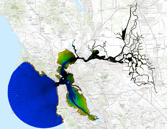
Present-day model grid
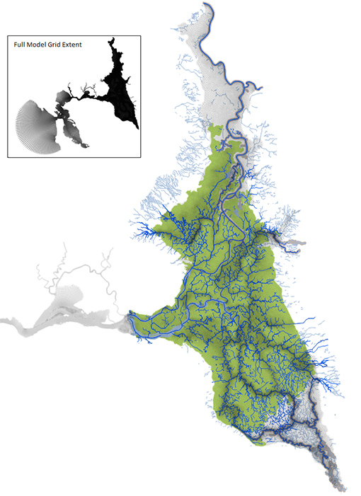
Historical Delta Model grid
The present-day RMA 3D San Francisco Estuary Model was calibrated using observed stage, flow, and salinity time series data and USGS Polaris water quality transect data. Calibration and validation runs were performed for 1994, 2010, 2012, 2013, and 2015.
The model is able to evaluate the local as well as regional hydrodynamic and water quality impacts of:
- proposed tidal marsh restorations
- levee failures
- modified Delta operations or temporary barrier deployments
- wastewater discharges
- droughts
- sea level rise
Post-processing computation and visualization routines are available to extract time series at specific points, 2D spatial maps, animations, and 3D surface visualizations of both model variables (velocities, salinities) and derived quantities (tidal ranges, stratification) from results files.
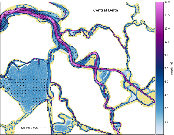
Example visualization of water surface velocities and depths in the central Delta